Includes

Marsaxlokk

Blue Grotto

Hagar Qim

Vittoriosa Waterfront

Price :- Euros17 Adult.

(15% discount applicable for pre booking only)

Pick up from Palazzin Hotel.

Operated on most days, but highly recommend Sunday for Marsaxlokk Market.

Special Prices for groups and children.

Book online.

Queries What app 0035699824020


The Perfect tour for South of Malta


Manoel Island (Maltese: Il-Gżira Manoel), formerly known as Bishop’s Island (Maltese: Il-Gżira tal-Isqof, Italian: Isola del Vescovo) or the Isolotto, is a small island which forms part of the municipality of Gżira in Marsamxett Harbour, Malta. It is named after the Portuguese Grand Master António Manoel de Vilhena, who built a fort on the island in the 1720s.

Manoel Island is a flat island shaped roughly like a leaf. It is located in the middle of Marsamxett Harbour, with Lazzaretto Creek to its south and Sliema Creek to its north. The island is connected to mainland Malta by a bridge. The whole island can be viewed from the bastions of the capital Valletta.[1]

For countless years in the 1950s a vast amount battleships were berthed in the Msida and Ta’ Xbiex marina. From the1960s right up until today, Ta’ Xbiex hosts many private boats with people from all nationalities making this location their berthing home for short as well as long stays.

The Msida and Ta’ Xbiex Marinas – many times referred to as the Sliema Marina – form the largest marina in Malta. These Marinas together provide mooring facilities for more than 700 boats on 15 serviced pontoons. It is located inside Marsamxett Harbour, which makes it safe and well sheltered, as well as conveniently central.

Msida is situated right on the coastal creek. Walking along the coast one can see various marinas, boat slipways as well as many locals fishing from shore,

Msida became a parish in 1867. Then the settlement was centered on the hovels located inward at Valley Road, and some nearby ancillary roads and pathways which led up to the quaint district of Villambrosa. This status did not last long however, as a new parish Ħamrun was hived off in 1881. Today the lowest part of Villambrosa Street remains a silent reminder of Msida’s jurisdiction in this area. Msida would also eventually see parts of its territory lost to new parishes at Santa Venera in 1918, Pietà in 1968 and Ta’ Xbiex in 1969.

Its population, which at one time numbered 11,500, thus also dwindled to a mere 6,000. However the recent aforementioned demands as well as residential developments in the outlying suburb of Swatar, have now seen an increase to more than 7600 inhabitants.

Today, Msida is a bustling university town and development has been centered on an increasing student population at the university as well as various new service industries that have sprung in this town in recent years.

The city houses many university students, mostly Gozitans.

The best part about the Valletta bus terminal? It’s right by the entrance to Valletta’s old town. The bus station itself is entirely outdoors and runs along two streets bordering a part of the fortress of the old town. In fact, the bus terminal is both a bus station and a public street..

Enjoy your visit to Valletta with a deep understanding of why and how the city was built and discover all of its treasures.

The harbour mouth faces north east and is bounded to the north by Saint Elmo Point and further sheltered by an isolated breakwater and is bounded to the south by Ricasoli Point. Its north west shore is formed by the Sciberras peninsula, which is largely covered by the city of Valletta and its suburb Floriana. This peninsula also divides Grand Harbour from a second parallel natural harbour, Marsamxett Harbour. The main waterway of Grand Harbour continues inland almost to Marsa. The southeastern shore of the harbour is formed by a number of inlets and headlands, principally Rinella Creek, Kalkara Creek, Dockyard Creek, and French Creek, which are covered by Kalkara and the Three CitiesCospicuaVittoriosa, and Senglea. The harbour has been described as Malta’s greatest geographic asset.[3]

With its partner harbour of Marsamxett, Grand Harbour lies at the centre of gently rising ground. Development has grown up all around the twin harbours and up the slopes so that the whole bowl is effectively one large conurbation. Much of Malta’s population lives within a three kilometer radius of Floriana. This is now one of the most densely populated areas in Europe. The harbours and the surrounding areas make up Malta’s Northern and Southern Harbour Districts. Together, these districts contain 27 of 68 local councils. They have a population of 213,722 which make up over 47% of the total population of the Maltese islands.[4]

Visitors at Fort St Elmo can enjoy a twofold experience. Originally intended as a war machine, the fort was built in a strategic location to face and hold back the menacing Ottoman attacks. This dominating position now offers unobstructed panoramic views of the harbours and the surrounding towns and villages. The fort also hosts the National War Museum which houses a superb collection of artefacts that go back to prehistoric times.

Constructed by the Order of St John in 1552, the star-shaped fort was built according to the cutting edge of fortress design. The fort played a crucial role in the eventful Great Siege of 1565 which saw the mighty forces of the Ottoman Empire and the Order of St John come head to head.


Visitors at Fort St Elmo can enjoy a twofold experience. Originally intended as a war machine, the fort was built in a strategic location to face and hold back the menacing Ottoman attacks. This dominating position now offers unobstructed panoramic views of the harbours and the surrounding towns and villages. The fort also hosts the National War Museum which houses a superb collection of artefacts that go back to prehistoric times.

Constructed by the Order of St John in 1552, the star-shaped fort was built according to the cutting edge of fortress design. The fort played a crucial role in the eventful Great Siege of 1565 which saw the mighty forces of the Ottoman Empire and the Order of St John come head to head.

During the British rule, the fort was modified to accommodate the new requirements of war. Right on the day when Malta became involved in the conflict of World War II, on 11 June 1940, Fort St Elmo suffered the first aerial bombardment on the islands.


One of the finest venues in the Mediterranean
The 16th century building now the Mediterranean Conference Centre has long been one of Valletta’s most remarkable landmarks. Located towards the tip of Valletta peninsula, the MCC stands for distinction with magnificent views across the Grand Harbour.

The Holy Infirmary was ordered to be built by Grand Master Jean de la Cassière on 7 November 1574, after a Chapter General, to replace the already existing one in Birgu. Construction instigated in the same year. It was completed towards the end of the 16th century. Its architect is not known,[8] but it is usually attributed to Girolamo Cassar.[9]

The Great Ward today
It was meant to receive Maltese and foreign patients, as well as to provide lodging to pilgrims travelling to the Holy Land. 

The Holy Infirmary was ordered to be built by Grand Master Jean de la Cassière on 7 November 1574, after a Chapter General, to replace the already existing one in Birgu. Construction instigated in the same year. It was completed towards the end of the 16th century. Its architect is not known,[8] but it is usually attributed to Girolamo Cassar.[9]


The Great Ward today
It was meant to receive Maltese and foreign patients, as well as to provide lodging to pilgrims travelling to the Holy Land. It also had two pharmacies. In 1596 a phalange was built, which was meant to accommodate the patients suffering from venereal and contagious diseases. In 1636, one of the pharmacies was closed down.

The Valletta Waterfront, is a promenade in Valletta,[1] Malta, mainly featuring three prominent buildings: a church in the middle, the Pinto Stores or the Pinto Wharf on the left, and the Forni Stores or the Forni Shopping Complex on the right. The buildings were originally stores and warehouses, built in the 18th century, and the design is attributed to Andrea Belli.

The building project was officiated on 10 August 1752, with a mass festivity. The Forni Stores were used as the first British naval bakeries in Malta and were used for this function until 1844.[2] The area is now a hub in Malta’s cruise liner business as the Forni Cruise Passenger Terminal, and hosts a concentration of bars, retail outlets, and restaurants. The area was and remains a venue for several concerts and events.[3]

The Hypogeum of Ħal Saflieni is a Neolithic subterranean structure dating to the Saflieni phase (3300 – 3000 BC) in Maltese prehistory, located in Paola, Malta. It is often simply referred to as the Hypogeum (Maltese: Ipoġew), literally meaning “underground” in Greek. The Hypogeum is thought to have been a sanctuary and necropolis, with the remains of more than 7,000 people documented by archeologists,[1] and is among the best preserved examples of the Maltese temple building culture that also produced the Megalithic Temples and Xagħra Stone Circle.

The Hypogeum was discovered by accident in 1902 when workers cutting cisterns for a new housing development broke through its roof.[2][3] The workers tried to hide the temple at first, but eventually it was found. The study of the structure was first conducted by Manuel Magri

Senglea,  or Isla, is one of the Three Cities located in the Cottonera area in the east of Malta. The locality was nicknamed an L’isola (an island) during the time of the Knights but it is actually a peninsula stretching out in the Grand Harbour. With an area of just 0.2km2, it is Malta’s tiniest town, and the most densely populated, hosting around 3,500 inhabitants.

This locality is one of the oldest cities in Malta dating back to the 16th century. It has a rich heritage as many buildings were constructed by the Knights of St John; enclosed by bastions that give spectacular views of the Grand Harbour. The narrow streets hold a number of beautiful aged buildings. Senglea got its name after Claude De La Sengle, the grandmaster who built it.

The noble military provenance of the Vittoriosa Waterfront has given way through the centuries to the glamour of the super-yachts that now speckle the dedicated dockyard. Vittoriosa’s wharf has been in use since Phoenician times. It was the primary naval base of the Knights of St John, and later of the Royal Navy. The Maritime Museum occupies what was once the British Naval Bakery, whilst the Casinò di Venezia is situated in the building of the former British Admiralty.The Vittoriosa Waterfront is now home to an array of fine restaurants, and provides a resplendent setting for a relaxed lunch or evening meal.

Birgu (MalteseIl-Birgu [ɪlˈbɪrɡʊ]ItalianVittoriosa), also known by its title Città Vittoriosa (“Victorious City“), is an old fortified city on the south side of the Grand Harbour in the South Eastern Region of Malta. The city occupies a promontory of land with Fort Saint Angelo at its head and the city of Cospicua at its base. Birgu is ideally situated for safe anchorage, and over time it has developed a very long history with maritime, mercantile and military activities.

The Notre Dame Gate, also known as the Notre Dame de la Grace Gate (ItalianPorta della Maria Vergine delle Grazie), the Cottonera Gate, the Żabbar Gate (MalteseIl-Mina ta’ Ħaż-Żabbar) or Bieb is-Sultan (Maltese for “King’s Gate”), is the main gate of the Cottonera Lines, located in CottoneraMalta. The gate was built in 1675 in the Baroque style, and it is currently used as the headquarters of the heritage organization Fondazzjoni Wirt Artna.

Construction of the Cottonera Lines began in August 1670, when there were fears of an Ottoman attack after the fall of Candia. The Notre Dame Gate was built in 1675 as the lines’ main gate, and its design is attributed to Romano Carapecchia[3] or Mederico Blondel.[4] The gate is located within the Notre Dame Curtain, between Notre Dame and St. James Bastions, facing the town of Żabbar. It is situated at the highest point of the Cottonera area, and its roof was used to relay signals between Valletta and the coastal defences on the eastern part of Malta.[5] The gate was originally protected by a drop ditch and a tenaille.[3]

Żejtun (MalteseIż-Żejtun [ɪzˈzɛjtʊn]) is a city in the South Eastern Region of Malta, with a population of 11,218 at end 2016.[1] Żejtun is traditionally known as Città Beland, a title conferred by the grandmaster of the Order of the Knights of MaltaFerdinand von Hompesch zu Bolheim in 1797.[2] Before that, the village was known as Casale Santa Caterina,[3] named after its patron saint and parish titular.

The old urban cores, called Bisqallin and Ħal Bisbut, largely retain their narrow medieval streets and ancient boundaries. Since at least the 19th century, the name Żejtun, or Casale Zeitoun,[4] has referred to the settlement which developed around these two core villages. Together with a number of small hamlets in the vicinity, the bulk of the conurbation forms the city of Żejtun, administered by the mayor and the Żejtun Local Council. Over successive centuries, Żejtun lost a number of villages and hamlets that used to form part of its territory, which originally covered most of the south eastern part of Malta. The city experienced extensive urbanisation over the seventies and eighties, with the completion of numerous infrastructural and urban projects designed to relieve housing pressure in the neighbouring Cottonera area leading to a significant increase to the town’s population.[5] The town, and its surrounding satellite villages, are said to typify the basic Maltese conception of village life.[6]

Marsaxlokk (Maltese pronunciation: [marsaʃˈlɔk]) is a small, traditional fishing village in the South Eastern Region of Malta. It has a harbour, and is a tourist attraction known for its views, fishermen and history. As at March 2014, the village had a population of 3,534.[1] The village is also known for the Marsaxlokk Market, which is mainly a large fish market which takes place along the seafront on Sundays, and a tourist market during all other days of the week. Inhabited and well-known since antiquity, Marsaxlokk was used as a port by Phoenicians, Carthaginians and also has the remains of a Roman-era harbour.[2] Originally a part of the city of Żejtun, the fishing village became a separate parish in the late nineteenth century.

Traditional luzzi and other larger and more modern vessels line the sheltered inner harbour. The village is also popular among locals and tourists alike for its walks around the coast and harbour,[3] its restaurants, as well as for its swimming zones.[4] Marsaxlokk Bay also includes a container freeport towards Birżebbuġa, a power station complex towards Delimara,[5] and a small ship-repair facility for fishermen.[6]

Marsaxlokk is sometimes referred to as Portus Herculis, due to the association of Marsaxlokk Bay with the Roman and Punic remains at Tas-Silġ.[7]

Saint Lucian Tower was built above the shore of Marsaxlokk Bay on the headland between Marsaxlokk and Birżebbuġa. According to local legends, a woman is said to have had a dream in which St. John advised her to tell the Grand Master to fortify the area around Marsaxlokk since an Ottoman attack was imminent. The woman told the parish priest, who told the bishop who in turn told Grand Master Alof de Wignacourt. The Grand Master did not give any importance to this, but that summer an attack really happened. Therefore, Wignacourt ordered the construction of St Lucian Tower, which was eventually built between 1610 and 1611.[1] The cost of construction was 11,745 scudi, 2 tari and 6 scudi. The tower was named after a church in France in which Wignacourt had been baptized.[2]

The tower’s design is very similar to the Wignacourt Tower in St. Paul’s Bay, but on a larger scale. A flight of steps led to the tower, but this was later demolished by the British. There are claims that it was designed by Vittorio Cassar,[3] but these are disputed since Cassar was probably dead when work on the tower began.[4]

.

Għar Dalam (“Cave of Dalam” (a fifteenth century family name), IPA: [aːr ‘dalam])[A] is a 144 metre long phreatic tube and cave,[1] or cul-de-sac, located in the outskirts of Birżebbuġa, Malta. The cave contains the bone remains of animals that were stranded and subsequently became extinct in Malta at the end of the Last Glacial Maximum. It has lent its name to the Għar Dalam phase in Maltese prehistory, and is viewed as one of Malta’s most important national monuments.[2] Pottery similar to that found in Stentinello was found at Għar Dalam, but lacking details such as stamp decorations.[3]

Dwarf elephant, hippopotamus, giant swan, deer and bear bone deposits found there are of different ages; the hippopotamuses became extinct about 10,000 years ago, whilst the deer species became extinct much later, about 4000 years ago during the Chalcolithic.[4] It is also here that the earliest evidence of human settlement on Malta, some 7,400 years ago, was discovered.

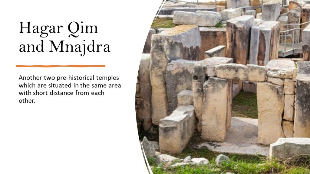
he Blue Grotto (Maltese: Taħt il-Ħnejja) refers to a number of sea caverns on the south east coast of Malta, a short distance from the fishing harbour limits of Wied iż-Żurrieq, of Qrendi,

Malta. Wied iz-Zurrieq, the blue grotto and neighboring caves, are all located within the Qrendi village confines, per Local Council Act 1993 and a 1910 legal dispute between the villages of Qrendi and Zurrieq over their jurisdiction, which ruled in favour of Qrendi.[citation needed]

Both the Wied iz-Zurrieq harbor and Blue Grotto sea caves are located on the coastline opposite to the small uninhabited islet of Filfla, [1] which is a bird sanctuary.

The location of the caves lead to the seawater reflecting shades of blue on the cave walls and ceilings.

Several caverns also mirror the brilliant phosphorescent colours of the underwater flora and fauna,[clarification needed][citation needed] whilst other caverns show a deep dark shade of blue.

Underwater, different colors of red, mauve, green, orange and yellow give an impressive picture to visitors.

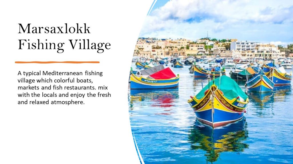
The Blue Grotto is a popular destination for tourists to Malta with boat trips visiting the caves running all days of the year, weather permitting.

Ħaġar Qim (Maltese pronunciation: [ħadʒar ˈʔiːm]; “Standing/Worshipping Stones”) is a megalithic temple complex found on the Mediterranean island of Malta, dating from the Ġgantija phase (3600-3200 BC).[1] The Megalithic Temples of Malta are among the most ancient religious sites on Earth,[2] described by the World Heritage Sites committee as “unique architectural masterpieces.”[3] In 1992 UNESCO recognized Ħaġar Qim and four other Maltese megalithic structures as World Heritage Sites.[4] V. Gordon Childe, Professor of Prehistoric European Archeology and director of the Institute of Archaeology in the University of London from 1946-1957[5] visited Ħaġar Qim. He wrote, “I have been visiting the prehistoric ruins all round the Mediterranean, from Mesopotamia to Egypt, Greece and Switzerland, but I have nowhere seen a place as old as this one.”[6]

Ħaġar Qim’s builders used globigerina limestone in the temple’s construction.[7] As a result of this, the temple has suffered from severe weathering and surface flaking over the millennia.[7] In 2009 work was completed on a protective tent.[8]

This website uses cookies to ensure you get the best experience on our website.